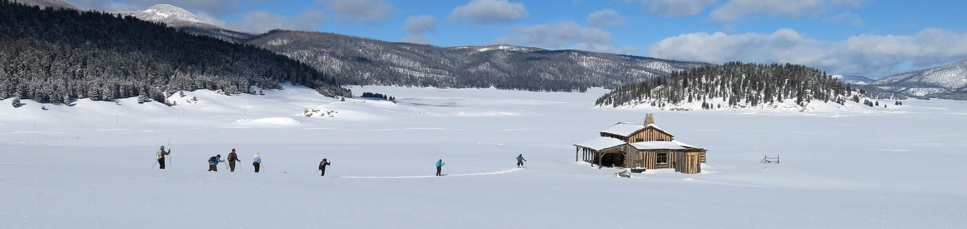
There are a number of cross-country skiing areas in the Jemez Mountains with trailheads along state route NM4. Traveling from west to east on NM4, they are, in order, Los Griegos/East Fork Ridge, Corral Canyon/Calzada, Coyote Call/Rabbit Ridge, and the Upper Frijoles trails in Bandelier National Monument. These areas, and many others, are discussed in detail in Sam Beard’s book “Ski Touring in Northern New Mexico”. Sam and other members of the New Mexico Cross-Country Ski Club laid out many of these trails and maintain them for skiers and hikers.
Los Griegos and East Fork Ridge
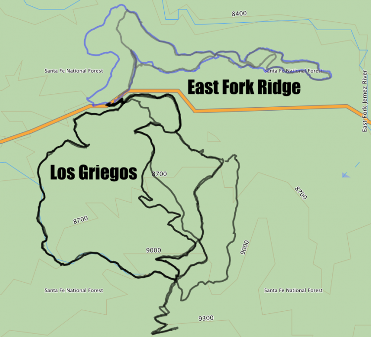
The adjacent figure shows the trail networks accessible from the Los Griegos parking area, which is just west of mile marker 35 on the south side of NM4. The trailhead for the Los Griegos network is at the west side of the parking area, and the East Fork Ridge trailhead is on the north side of NM4, a little east of the parking area.
The Los Griegos (LG) area has the most extensive network of trails in the Jemez. It has been spared wildfire damage so far (2016), and, as a result, is forested and is an aesthetically inviting winter outing. Most of the trails in the network are shown in the above figure. The trailhead is at 8420′ and most of the trails climb to Griegos Junction (GJ) at 9090′. Trips can be extended from GJ up to Upper Road at 9320′. Los Griegos trailhead is not the highest one in the Jemez, but because of the sun-shielding forest and the north-facing slope, on which the trails have been developed, it frequently has the best snow
Ladera/Squirrel Canyon Loop
GPX file: Ladera/Squirrel Canyon (zipped)
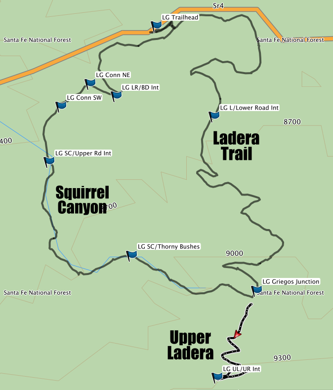
The Ladera Trail is one of the most popular for access to GJ (LG Griegos Junction), and there are several options for descending from there. On the graphic, Ladera is the eastern trail from the trailhead (LG Trailhead) to Griegos Junction, and Squirrel Canyon is the one on the west. Ladera is gentle and winding, and, under ordinary conditions, skins are not required for climbing. At several points, Ladera is near enough to Lower Road that one can exit to the road and descend or take alternate routes back to the trailhead. An intersection with the road is marked (LG L/Lower Road Int). An unmarked, short connector trail branches from Ladera and crosses Lower Road at its intersection with Elk Ridge Trail (discussed below). From GJ, Ladera continues as Upper Ladera to Upper Road (LG UL/UR Int). The section of Upper Ladera below the switchbacks is a wide cut through an aspen grove, and is worth the extra climb from GJ for a nice bit of cruising on a powder day. One can continue climbing Upper Ladera to an intersection with Upper Road on a switch-backed trail. About 0.30 miles to the east, is the Valle Grande Overlook with views of the eastern Jemez Mountains. Unfortunately, the Las Conchas fire has reduced the aesthetic appeal of the views, but they do reveal the devastation that the fire wrought. A traditional picnicking spot is “Sunny Ridge,” which is south of Upper Road and about 0.6 mile southeast of the Upper Road/Upper Ladera intersection.
From GJ, the route shown descends Squirrel Canyon. There are narrow and broad sections, and the grade is mostly gentle. The descent can be tricky, especially if the snow is marginal. There are several steep, sometimes narrow, sections on which an intermediate skier might exercise caution. A cluster of thorny bushes is noted on the map, and, it’s at the bottom of a rather steep descent, so caution there is prudent. On a powder day, the reward is some fine cruising, usually through unbroken snow. (Squirrel does not attract as much traffic as most of the other LG trails.) If one is climbing that section, skins will help.
The canyon ends at Upper Road, as shown, and one can follow Upper Road out to NM4, if desired. A better return to the trailhead is to turn east at Lower Road, which is NOT shown on the map, and follow it to the Black Dog Canyon. Alternatively, an unmarked shortcut to Black Dog is shown on the map between waypoints, (LG Conn SW“)and (LG Conn NE). Although it is unmarked, the trail is pretty well-defined through dense forest to a parking area on Lower Road. The linked GPS track follows that path to Lower Road. After a short section on Lower Road (to the waypoint marked (LG LR/BD Int), the trail turns back to the NW and down into Black Dog Canyon, which leads over a low ridge, and then back to the trailhead.
Specifics:
- Trailhead to GJ via Ladera: 2.1mi; 600’elevation gain
- Trailhead to GJ via Squirrel Canyon: 2.0mi; 600’elevation gain
- GJ to Upper Rd via Upper Ladera: 0.4mi; 200′ elevation gain
Elk Ridge/Pine Canyon/Lower Road
GPX File: Elk Ride/Pine/Lower (zipped)
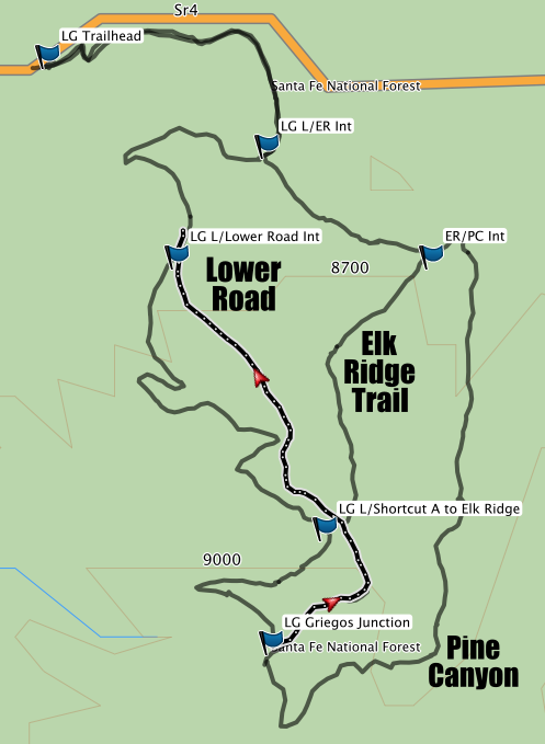
The figure shows four tracks. From left: Ladera (for reference), Lower Road, Elk Ridge, and Pine Canyon.
Elk Ridge Trail
To climb Elk Ridge, follow Ladera from the Los Griegos trailhead to the intersection with Elk Ridge trail (LG L/ER Int) and turn to the east. The trail is steep enough to justify skins. At the ridge line (LG ER/PC Int), where a power line passes above, the trail continues up and to the south. Pine Canyon is the canyon below and to the east of this intersection. The skins will continue to be appreciated as you climb to the intersection with Lower Road, near (LG L/Shortcut A to Elk Ridge). Griegos Junction can be accessed either by turning left on Lower Road, or by crossing the road and taking a very short connector to Ladera Trail, which leads up to Griegos Junction. The reverse trip can be a lot of fun, especially on a powder day, when the descent can be speedy and exhilarating. Deep powder and berms in the road can slow an otherwise perilously fast descent.
Pine Canyon
Pine Canyon is unmarked and not maintained. However, it is a broad, shallow drainage in which it is easy to follow animal trails. From Griegos Junction, follow Lower Road as it continues south. Within a few hundred yards, Pine Canyon drops off to the left. It’s a gentle, unmarked descent through a mostly wide-open drainage. An overhead power line provides a landmark indicating the point at which to turn west. Stay alert for this landmark-the canyon goes out to NM4, but the bushwhacking back to the trailhead is pretty unpleasant. Follow the path north as you climb up the switchback to Elk Ridge Trail. It’s vigorous, but skins are normally not required. At the top of the ridge meet Elk Ridge Trail and ski down. The trip down to Ladera is steep and can be pretty speedy. There are a number of wide, relatively level areas where one can turn uphill to control speed.
Lower Road
The fragment of Lower Road that leads from its intersection with Ladera (LG L/Lower Road Int) is shown in the figure above. (From that point Lower Road descends to its intersection with Black Dog Canyon (LG BD LR Int). That section is not shown because it faces south, and with any sun, the snow can be pretty wet and heavy.) The fragment shown is steep, and if climbing, you’ll probably want skins. From Griegos Junction, it’s probably the fastest way back to the trailhead. In deep powder it can be fast and exciting, but under the snow, it’s a deeply-rutted and rocky road, so it’s best if the snow is really deep. It’s also exposed to the sun, so the snow can be heavy.
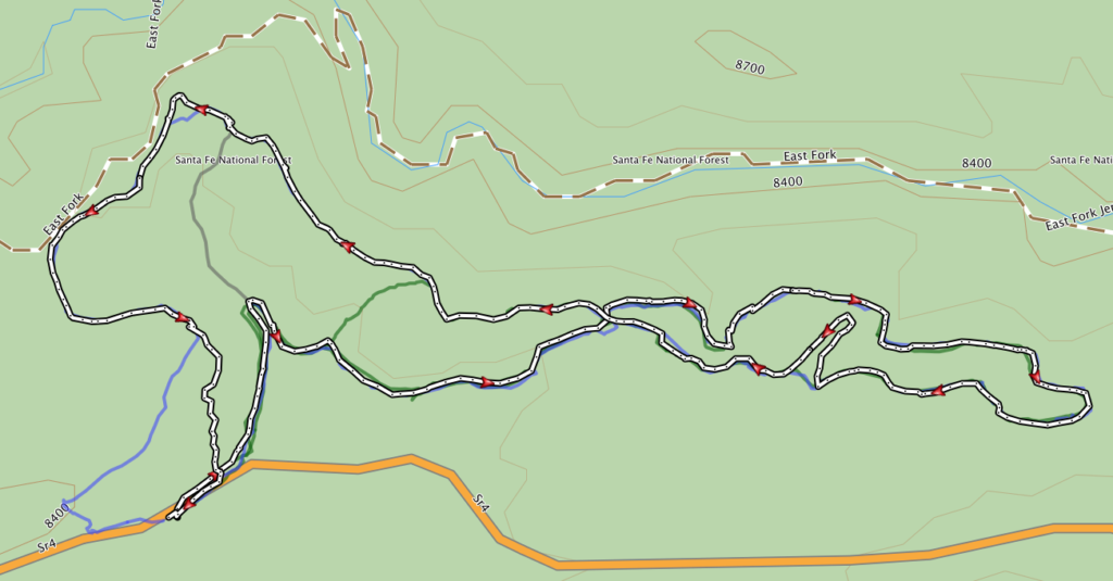
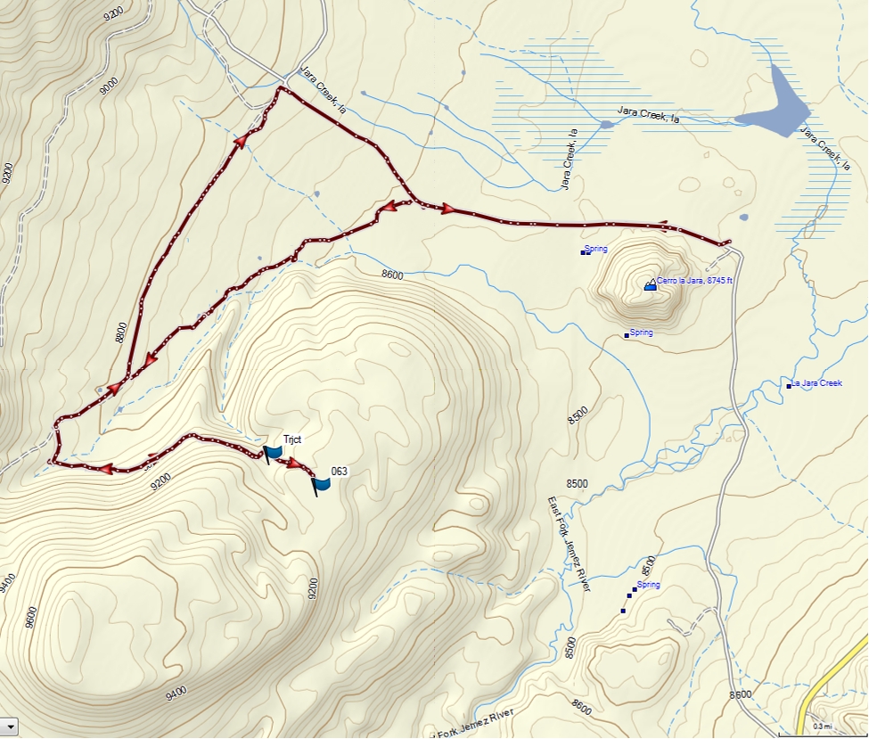
East Fork Ridge Trails
The adjacent graphic shows the major trails in the East Fork Ridge area, that are accessible from the Los Griegos parking area. The East Fork Hiking Trail is shown as a brown/white dashed line on the map. Its trailhead 2.5mi west on NM4 and it can be a nice cross country ski tour, but near the trailhead, it gets a lot of snowshoe and hiking traffic. There is significant sun exposure as well, so it is best skied shortly after a fresh snow.
This tour is shown on the adjacent map, and is part of a larger network of trails on the north side of NM4. See Sam Beard’s “Ski Touring in Northern New Mexico” for a description of this trail and others in the vicinity. The route shown is ~3 miles long and the elevation gain is ~200′. The trailhead is a gate that is ~50 yards east of the Los Griegos parking area, which is just west of NM4 mile marker 35. Park on the east side of the lot to shorten the trek to the gate on the north side of the road.
GPX File: East Fork Basic Loop (zipped)
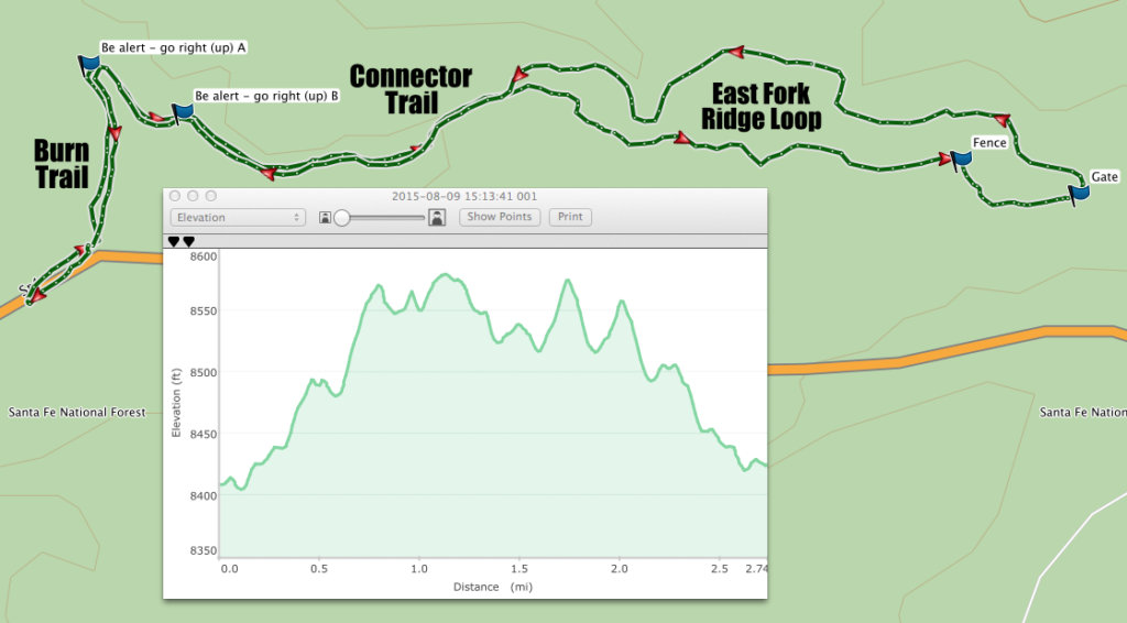
An elevation profile, corresponding to a tour that follows the arrows on the track, is also shown. The Burn and Connector Trails comprise the stem of the lollipop, where most of the elevation change occurs. Much of this section has southern exposure, and with sparse snow coverage and/or heavy traffic this section can be difficult, especially descending. At least one scapula has been broken on the narrow path. Blue diamonds mark the trail, but the map shows two points where alternate paths leave the main trail and the skier should be alert to the blazes.
The loop is the inner ~2 miles on the elevation profile, and the elevation does not fluctuate enormously. The loop is on the north side of the ridge, and the trees and northern exposure make for good snow coverage. The author’s preference is to follow the loop as indicated by the arrows, i.e. in a counter-clockwise direction. The south branch has some twisty, narrow sections with possibly exposed rocks and roots, and these are easier to negotiate skiing uphill.
On the return, the north side of the loop has some wide, gentle, extended sections that can provide some euphoric skiing on a powder day. The trail gets little traffic, and such days are not rare. A waypoint marks a fence that has a gap in it (Fence), but stay on the trail with the fence on your left until you reach a gate (Gate) and proceed north through it.
The trail is located in nicely spaced stands of forest and has not recently burned. Sam Beard and his crew maintain this trail, and obstacles are frequently cleared. Blue diamonds blaze most of the trail, but even when they are not visible, the path is usually clear.
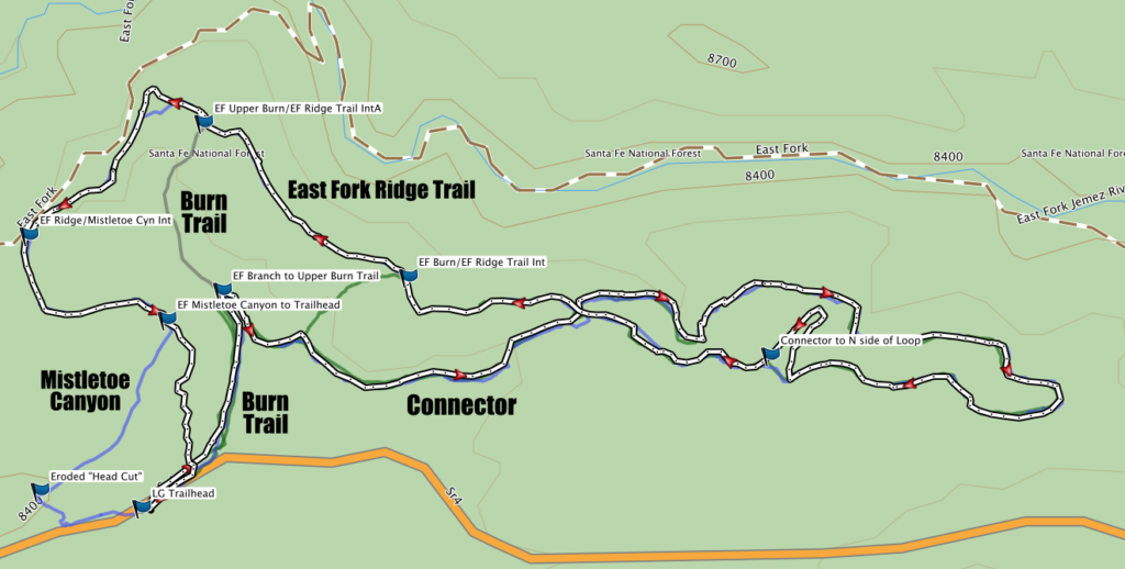
GPX File: East Fork/Burn/Mistletoe (zipped)
The other major trails that branch from the loop discussed above are shown in the adjacent graphic. East Fork Ridge Trail comprises the northwest section of the network. Mistletoe Canyon Trail leads from the East Fork Ridge Trail back to NM4 , intersecting it a few hundred feet from the parking area. Caution should be exercised following the westernmost branch because it passes very near a “head cut” (Eroded “Head Cut”); a very deep erosion channel.
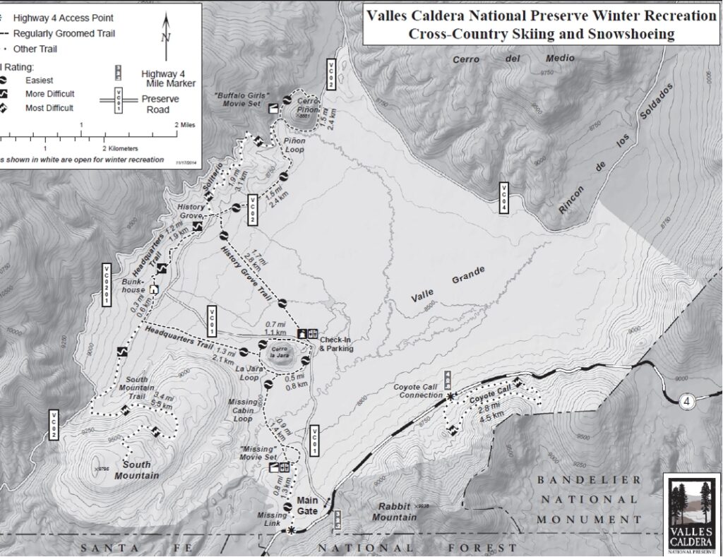
Valles Caldera National Preserve
Maps of the VCNP Routes (for further information, visit the Valles Caldera National Preserve website)
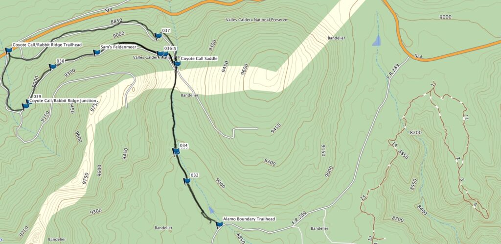
Coyote Call Trail
South of State Road 4 in the VCNP